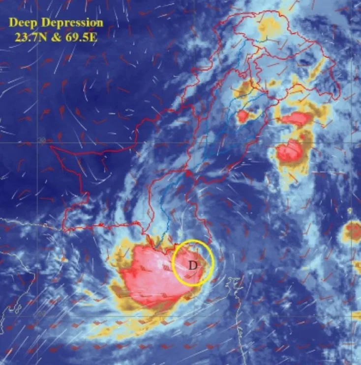
The Pakistan Meteorological Department (PMD) has issued a warning as a deep depression (DD), a very strong low-pressure area, over the Rann of Kutch in India continues to move slowly towards the west-southwest.
As of the last 12 hours, the system was located at Latitude 23.7 N and Longitude 69.5 E, approximately 270 kilometers east/southeast of Karachi. The Met Office has informed that the system is expected to move further west-southwest and emerge into the northeast Arabian Sea along the Sindh coast by late tonight or tomorrow morning.
Due to favorable environmental conditions, including high sea surface temperatures, low to moderate vertical wind shear, and upper-level divergence, the system is likely to intensify into a Cyclonic Storm (CS) by tomorrow. It is projected to continue moving initially in a west-southwest direction.

The Met Office has forecast widespread rain and wind-thunderstorms, with heavy to very heavy rainfall and isolated extremely heavy falls expected in several districts, including Tharparker, Badin, Thatta, Sujawal, Hyderabad, Tando Muhammad Khan, Tando Allahyar, Matiari, Umerkot, Mirpurkhas, Sanghar, Jamshoro, Dadu, Shaheed Benazirabad, and the Karachi division. This weather pattern is expected to persist until August 31, with occasional gaps.
The sea conditions are predicted to be rough to very rough, with squally winds reaching speeds of 50-60 km/h. In light of this, fishermen have been strongly advised against venturing into the sea until at least August 31.
The PMD’s cyclone warning center in Karachi is closely monitoring the situation and will continue to provide updates as the system evolves. Concerned authorities have been urged to stay informed through the PMD advisories and take necessary precautions.
Residents and authorities in the affected areas are advised to stay updated with the latest information and advisories from the PMD to ensure safety and preparedness as the situation develops.
Read More: Earthquake in Islamabad and Peshawar adjoining areas


